Resources
 Part of the Oxford Instruments Group
Expand
Collapse
Part of the Oxford Instruments Group
Application Notes
Author: A. Hilboll, Institute of Environmental Physics, University of Bremen
Published: 01 Jul 2018 · Last updated: 16 Jul 2025
Tags: absorption-app
Nitrogen dioxide (NO2) is a key pollutant in the atmosphere. While being toxic and harmful to humans, it is also responsible for the creation of the tropospheric ozone and plays a key role in the formation of acid rain.
NO2 is created by high-temperature combustion processes; its main emission sources are combustion of fossil fuel, industrial processes, but also natural biomass burning and lightning. Remote sensing measurements using Differential Optical Absorption Spectroscopy (DOAS) are one method that can be used to observe key trace species in the atmosphere including NO2, O3, HCHO, CHOCHO, and water vapor.
With the development of flexible multi-axis (MAX-DOAS) instruments information on the vertical distribution of the trace species can be retrieved. By pointing the instrument into different azimuths, the horizontal variability around a measurement location can be assessed.
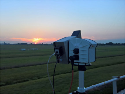
Figure 1: The IMPACT imaging MAX-DOAS instrument
MAX-DOAS instruments are basically UV/visible spectrometers observing scattered sunlight in different viewing directions towards the sky. In the novel Imaging Mapper for Atmospheric Observations (IMPACT) developed at IUP-Bremen, a grating spectrometer equipped with a cooled 2-D CCD detector is used to measure visible light (425–490 nm).
The light is collected with a separate telescope unit connected to the spectrometers via a split quartz fibre bundle. The spectrometer is temperature stabilized to avoid wavelength drifts. The quartz fibre bundle efficiently depolarizes the incoming light and also provides flexibility for instrument set-up. The telescope unit is mounted on a commercial pan-tilt head which enables us to point the telescope to almost every direction (see Fig. 1).
The telescope optics are designed to measure in a range of elevation angles (above the horizon) simultaneously, so the 2-D image on the CCD contains, at each time, spectral information in many elevation angles.
Therefore, this set-up allows for performing a full hemispheric spectral measurement within ~30 minutes, as only the azimuth direction has to be changed (contrary to traditional MAX-DOAS instruments which only measure one elevation angle at a time).
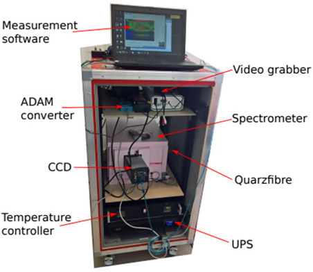
Figure 2: The IMPACT imaging MAX-DOAS instrument. The spectrometer is temperature-stabilized and located inside the pink box.
In order to get a very good signal to noise ratio and a good spectral resolution, a combination of the Shamrock SR 303i-A spectrograph and the back-illuminated Newton DU940P-BU CCD detector was chosen (see Fig. 2).
In September 2016, IMPACT participated in the international intercomparison campaign CINDI-2 in the Netherlands, where more than 30 MAX-DOAS type instruments were deployed in an effort to further harmonize and improve the MAX-DOAS technology (http://www.tropomi.eu/data-products/cindi-2).
IMPACT did very well compared to the state-of-the-art traditional MAX-DOAS instruments, considering that the traditional instruments apply full vertical binning for optimal signal to noise. The instrument was able to capture a full hemispheric snapshot of NO2 column every 30 minutes (see Fig. 3).
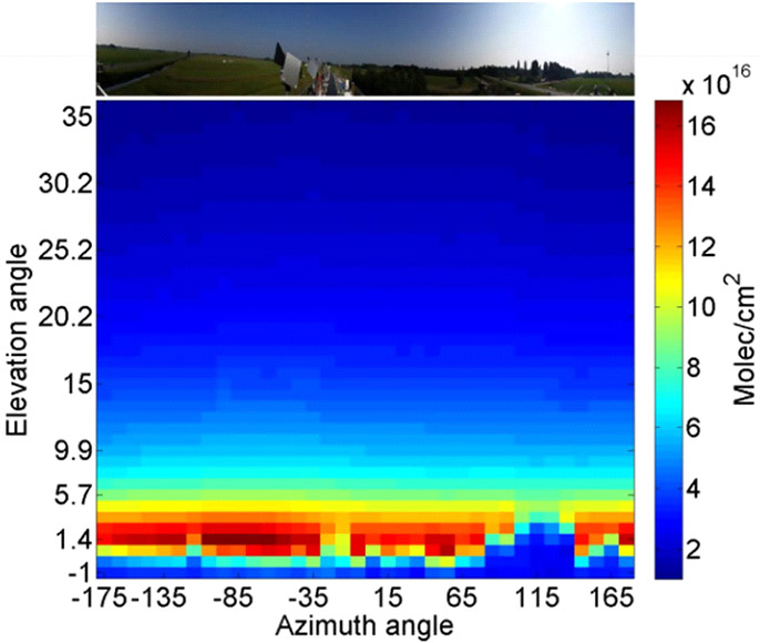
Figure 3: Hemispheric view of mean NO2 columns and panoramic view of instrument field-of-view during the CINDI-2 campaign.
These results show that IMPACT is able to locally capture the horizontal and vertical variability of NO2 at an unprecedented temporal resolution. For example, in summer 2017 the instrument was deployed on the research vessel Kommandor Iona on a research cruise around the Arabian Peninsula to measure pollution in the Middle East.
Since the imaging setup of the instrument allows measuring all elevation angles simultaneously, the time required to record a vertical cross-section of NO2 columns is greatly reduced, allowing for one data point per direction every two minutes. While the ship is moving, this allows identification of very local, isolated pollution sources such as oil rigs in the Arabian Gulf.
References

© Oxford Instruments 2026